Mada'in Qum Salih Jibal were carved with high precision

Mada'in Saleh, previously known as Al-Hijr, is an archaeological site located in the Hejaz region in the Arabian Peninsula, northwest of the Kingdom of Saudi Arabia, specifically in the Al-Ula Governorate of the Medina region. The place is strategically located on the road that connects the southern Arabian Peninsula with Mesopotamia, the Levant and Egypt, and the place has a historical fame that it derived from its location on the ancient trade route linking the south of the Arabian Peninsula and the Levant, and Al Hajar is the name of Diyar Thamud with the Wadi Al Qura between Medina and Tabuk. The stone was mentioned in the Qur’an as the home of the people of Thamud, who responded to the call of the Prophet of God, Saleh, and then turned away from their religion and devoured the camel that God sent for them in a verse and destroyed them with the shouting Madain Saleh is considered one of the most important urban areas of the Nabateans after their capital, Petra, as it contains the largest southern settlement of the Nabatean kingdom after Petra in Jordan, which separates it from it by a distance of 500 km, and its most prominent civilizational roles date back to the first centuries B.C. Its fall at the hands of the Roman Empire in 106 AD, and it is believed that the Hegr continued in its civilization until the fourth century AD, and it was the capital of the Kingdom of Lahyan in the north of the Arabian Peninsula .
The ruins of Mada'in Saleh include 153 carved rock facades, as well as a number of Islamic monuments, which are represented by a number of castles and remnants of the Hejaz railway, which extends for a distance of 13 km, as well as the station and locomotives. In 2008, the site was registered on the World Heritage List, making it the first site to be registered in Saudi Arabia , There is also another archaeological site known as Mada'in Shuaib located northwest of Mada'in Saleh and it follows the Tabuk region, where the site contains monuments very similar to those in Mada'in Saleh .
History
Kingdom of dedan

An anthropomorphic figure of a man found in the temple of Mahlab a camel, dating back to the fourth century BC
It is a kingdom subordinate to the Kingdom of Ma'in from the fifth century B.C. until the beginning of the first B.C. It was established in al-Hijr and the northwestern parts of the Arabian Peninsula, and it is most likely that it is a previous stage of the Kingdom of Lehyan, where some researchers believe that the Lihyanites were residents of southern Arabia. To Hayyani in Yemen, his name was "Father Leah Dhu Lahyan" and they settled in Worms south of the lands of Lahyan. When the Maeen government weakened in Yemen, the Lihyanites took over the kingdom and named it after their tribe, [8] and the researchers did not agree on their exact origins, and Jawad Ali believes that the Mawinites formed Colonies in the upper Hijaz since the fifth century B.C. He described them as the Lehyanites in the days of the Mawinite power, and the goal of these colonies is to secure the trade route from Yemen to the Levant, according to Warner Kaskell:
Mada'in Saleh It is worth noting that the Old Testament has a lot to say about the Sabaean, and it is clear that it is silent about the Maenin, but we do find a mention of worms and he appeared in the genealogies placed in the Old Testament as the brother of Sheba (Genesis 10: 7), which has one explanation, when the Old Testament talks about the Worms. What is meant is Ma'in and the reason for that use is clear, because the caravans of the southern Arabian kingdom of Ma'in used to stop in worms and did not pass them, so their citizens in that colony transported goods to other stations. The goal of this colony is to shorten the hardship of travel for those appointed. Madain Saleh
Most of their goods coming from the south of the Arabian Peninsula were destined for Egypt and Greece, and Kaskell believes that the Lihyanites seized them in the middle of the second century BC, around 150 BC. The Maenids were in control of the Hijr and the upper Hijaz from the fifth century BC with the help of the Lihyanites indicating that the first Their kings were appointed and then returned to Alhayan, taking advantage of the weakness of the kingdom of Ma'in and its wars with the Kingdom of Sheba. Jawad Ali believes that the Lihyanites are descended from the Prophet Ismail, and Pliny considered them the greatest among the Arab peoples as well.
The Lehyanites

Historians disagree about the origin of the Lihyanites, some of them see that they are a branch of Thamud, while others see that they are one of the southern Arab peoples, evidenced by the fact that the name of Lahyan was mentioned in a southern Arabic text. Al-Ula was the center of the Hayyanites, as it was an ancient Maaina colony, and it is the northernmost base of the South Arab civilization, located in Wadi al-Qura, southeast of Harrat al-Awarid, between a series of mountains in the east and west, and about 15 km south of Mada'in Saleh, there is a site In the past it was called “Dedan” or “Worms” according to what was mentioned in the books of the Jewish genealogy and in the specific texts, and later it was called Wadi al-Qura, now known as Al-Ula.
The influence of the state of Lahyan extended over the land extending west of Al-Nafud, from north of Yathrib to what borders the Gulf of Aqaba, and it differed in the period of the state of Lahyan, some believe that it was between the beginning of the fifth century and the end of the third century BC, and others believe that it was between the second century before Birth (about the year 160 BC) and between the end of the third century AD, and there are those who determined the period between 280 - 200 BC for its rise, and that its end was at the hands of the Nabataeans who seized the "Hijr" in the year 65 BC. AD, and "worms" in the year 9 BC. M.
In Al-Ula, near Madain Saleh, nearly four hundred Hayyani inscriptions were found, most of them are inscriptions and small pieces, including some that contain some names of kings and pagan deities. As for the Lehian script, it is a local script whose letters are sublime in the south and very close to the southern Arabic and Ethiopian writing The dialect is North Arabic, and it is also Southern Semitic. Some believe that she was Christian, while others think that it was an Arab Jahiliyya developed before the advent of Islam. These inscriptions and writings contain some of the names of the kings of Lahyan, including “Hnus bin Shahr” and “Dhu Akhma Bin Luthan” whose rule dates back to the first half of the first century before Christmas and there is a temple located in Al-Ula that dates back to the Hayyanites, in which statues were found tall by the kings of Lahyan, and these statues are influenced by the Pharaonic sculpture in the upper half of the body, and in terms of clothing, but they bear the Arab character represented in the shape of the face, and what was placed on the head with something like a turban And headband.
Some believe that the Nabataeans captured Hegra in 65 BC. M., until they reached Tayma, and then cut off all contact of the Hayyanites with the sea, so they seized the port of "Loki Kuma" belonging to the Alhayanites, and surrounded them from all sides, and it is believed that the trade route changed its direction by the action of the Nabateans in the south of Al Hajar, so it was passing at a distance of 7 km To the east of the ancient Dedan oasis, and then subjugated them to their influence. The rule of the Lihayanites returned again after the fall of Petra at the hands of the Romans in the year 106 AD, who extended their influence to an area ten kilometers to the north of Worms
Nabataean kingdom

The ancient Nabataean trade routes and the Hijr (Mada'in Saleh).
The Nabat (Nabateans) settled in Hijr, and the Nabateans are Arabs from the north of the Arabian Peninsula. In the first century BC, during the reign of al-Harith IV, he made al-Hajr the second capital of the Nabataeans, as their first capital was Petra in the north, and the Nabataeans had a great civilization and built tombs in the mountains and added to them many of the aesthetics of the old building, where the characteristics of Nabatean architecture appear with Nabataean writings Carved into the rocks on their facades. They have also developed oases cultivation, digging wells and making rainwater reservoirs in the rocks, in addition to carving places of worship in the rocky outcrops. There are facilities and settlements similar to what Mada'in Saleh contains in a number of places such as the Levant and the region adjacent to Hejaz, and the most prominent of these is what was found in Petra.
The Nabataean civilization continued to prosper and expand in stone until they controlled the trade routes in the ancient world, as they monopolized the trade of incense, myrrh and spices, and the ancient trade route came from the south of the Arabian Peninsula until it reached the stone, and from the stone it branches into two roads, one of which goes to Petra and Egypt And the Levant, while the other goes to Taima and then Palmyra in Iraq. The stone was also a major center for the ancient caravan routes and it controlled the caravan routes, and their influence reached as historians mention the east and south of the Arabian Peninsula, and when the Romans feared for their influence and their state from this new kingdom, the Romans launched a great war on the Nabataeans and the Romans were able to defeat them in Hegra in 106 AD But they did not settle in Al-Hijr but rather returned to the Levant. Thus, the Nabataean civilization was destroyed in Al-Hijr and no longer had any mention of them, and the stone remained deserted for a long time.


Post-Nabatean period
In the year 106 AD, the Nabataeans Kingdom was annexed by the Roman Empire and thus became a part of the Hijaz, which includes the stone under their administration. Recently a Roman inscription was discovered in stone dating back to 175 - 177 AD. A sea route through the Red Sea, which led to the decline of its commercial importance after it was a center of trade, until it was abandoned later. There are archaeological studies that assumed that the site had lost its urban functions in the early late antiquity, and this is due to the desertification process in the region recently. The discovery of evidence that the Roman legions during the reign of Trajan controlled Mada'in Saleh, to increase their influence in the Arab province.
Map showing the route of the Hejaz Railway
Mada'in Saleh Station in 1909
The history of the stone remains from the collapse of the Roman Empire until the emergence of Islam is unknown. In the year 9 AH corresponding to the year 630 CE, the Prophet Muhammad passed by while heading for the invasion of Tabuk. After the emergence and spread of Islam, the movement returned to the stone, as it was mentioned in the following centuries by travelers and pilgrims on their way to Mecca, where the stone served as a stop to rest in and to provide water and food and was mentioned by many Arab travelers such as al-Maqdisi, Yaqout al-Hamwi, Ibrahim bin Shuja, and Ibn Battuta, who In the fourteenth century AD he referred to the rocks and mausoleums in them, but he did not refer to human activities there under Ottoman rule, which began in the sixteenth century. A fortress was built in it between 1744 - 1757 AD, which was part of a series of fortifications that were built from In order to protect the pilgrimage road to Mecca.
Cities in the twentieth century
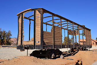
Since the nineteenth century, the existing wells to cultivate the area were used periodically by settlers in neighboring Tayma, and this continued until the twentieth century, when the Hejaz Railway (1901 - 1908 AD), which was passing through the site, was built by order of the Ottoman Sultan Abdul Hamid II, To connect Damascus and Jerusalem in the northwest to Medina, to facilitate the pilgrimage journey, in addition to political and economic matters to strengthen the Ottoman administration over the centers of the Islamic faith, the Mada'in Saleh station was built north of Al-Hajar, and it worked to increase the accessibility of the site. Later, the railway was destroyed by the British during the Arab Revolt during the First World War.
Several archaeological studies continued at the site for the period from the beginning of the First World War to the unification of the Kingdom of Saudi Arabia in 1932, until it reached the sixties AD. Later the railway station was restored, and it consists of 16 buildings distributed on the railway line with a length of about 400 meters, and includes buildings for administration and stores A police station, a health center, accommodation for workers at the station and rest stops for visitors, as well as a station for the maintenance of locomotives, a workshop for maintenance, and stores for firewood and energy.By the end of the sixties, the Saudi government implemented a program to improve the lifestyle of the nomadic tribes that inhabit the region, and the program proposed their stability in the region with reuse Existing wells and farming, but with the site's acquisition of its official identity as an archaeological site in 1972, it led to the settlement of the Bedouins to the north, outside the site’s boundaries, and this included the development of new agricultural lands and newly dug wells, to preserve the area.
Sculpture
.jpg)
.jpg)
The upper side of the tombs is characterized by terraced terraces on both sides and is known as the "crow's ladder."
Inscriptions and beams above the entrance and below the balconies
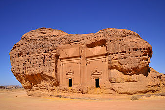
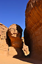
The Nabataean cemeteries in Mada'in Saleh are distinguished because they are not built, but are excavated in sandy rocks, which contributed to the ease of carving and digging, as these rocks are not solid, but are affected by erosion factors. The colors of the rocks vary from red to white according to their age, as the red rocks date back to the Cambrian period, while the white rocks date back to the Ordovician era, and these rocks coincide with those used by the Nabataeans in Petra, and there are several analyzes made by experts in archeology to explain the style of carving They saw that the process was carried out from the top to the bottom and since the owners of these tombs are from the ruling class or wealthy Nabateans, there were criteria before the carving process, as the location of the tomb is chosen, so the closer it is to the houses, the more expensive it is and the lower the distance from it, and the higher the rock And their quality was among those criteria as well, as the rocks that are devoid of cracks and cracks work to highlight the details of the inscriptions, such as the terraced terraces known as the crow ladder, the Egyptian-style cornice, lintels and column capitals that are carved on good rocks, but sometimes the sculptor is unable to know the quality of the rock at the beginning to be They are discovered later during carving, and the height of the burial is precisely determined according to the tools available to them. [53] When there is no natural layer protruding in the rock, a horizon channel is carved. A yard in the rock above the highest point of the carved façade, to prevent rain on the façade.
.jpg)
.jpg)
A burial chamber from the inside, and the burial chamber has one of three forms, either a niche, a pit, or a solid chamber.
Parts of the façade such as the space between the balconies, the lintel and the crossbar below the capital of the column are plastered and painted in a black or red color, as there are a number of tombs that still retain traces of the stucco used. In addition to carving and engraving tools, sculptors used measuring tools, including a vertical line gauge, a plane plumb, a square, a rope, and sometimes a caliper. There are a number of incomplete burials at the site, most of which are apparently due to artistic aspects, either because the sculptor encountered a salt layer that came from the surface of the earth, or it was due to a crack in the rock that did not appear at the beginning of the carving work, or the appearance of a layer containing On a lot of gravel.
The other element in the tomb is the burial chamber and it is excavated in the rock behind the façade, and the burial chambers are not usually at the same level as the height of the facades, and the level of the ceiling of the room is consistent with the upper threshold of the door, and the only tool used within the tombs was the pickaxe at the ends, and there are a number of burial chambers not This may be due to the fact that the owner of the tomb is more interested in the external facade than the inner room, and the carved burial place inside the room consists of three types, a niche, a pit, or a solid room, and it was carried out when a family member dies, and when the place is in the form of a room, it is excavated according to The size of the deceased person, and the burial chambers are usually irregular.
Researcher Jean-Claude Pisac estimated the period required to implement a medium-sized burial by one year and two months, and the digging of the facade would take the longest period, which could take seven months, and the tomb chamber would take between four to five months, which is roughly the same time required for the process of carving out details.
Writings and inscriptions
An inscription in Arabic in the Nabataean alphabet inscribed on one of the shrines.
The writings found in Mada'in Saleh vary, as there is South Arabic, Lihyaniya, Thamudian, Nabatiyeh, Latin, and Islamic. The subjects of these inscriptions vary between religious inscriptions, founding inscriptions and memorial inscriptions. Most of the inscriptions on the site are the royal inscriptions. The Nabataean inscriptions are spread on the site, as the site reached the height of its prosperity during the Nabatean era. Texts specifying the penalty that should be imposed on anyone who violates the burial law, and some inscriptions are dated and contain the name of the sculptor
Photo Gallery
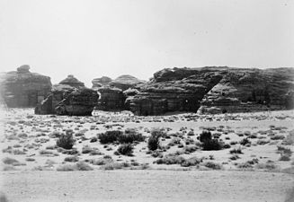
Madain Saleh year 1908 AD
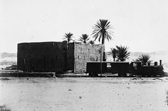
A locomotive belonging to the Hejaz train in 1908 beside a water tank in Mada'in Saleh for pilgrims

Fee for Madain Saleh station, one year 1913 AD

A drawing of the Alfred Palace by Wehbe Al-Hariri in 1979


.jpg)
.jpg)
.jpg)
.jpg)
.jpg)
.jpg)
.jpg)
.jpg)
.jpg)
.jpg)
.jpg)
.jpg)


.jpg)
0 Comments